Charles Bush, former attorney for the Gates Cooperative, recently recounted the seesawing and at times even violent past of the area just north of Sausalito called Waldo Point. Here is a lightly edited digest of his remarks, leading up to the houseboat wars of the 1970s:
Part I — Boats on Streets
The history of Waldo Point switches back and forth between law and reality, between what the law said should be at Waldo Point and what in fact was there.
Legally, Waldo Point, like all of San Francisco Bay, is governed by the Public Trust Doctrine which says that lands covered by the sea up to the line of mean high tide are owned by the state in trust for purposes of commerce, navigation and fishing.
In the early 1850s, the cash-strapped State of California passed a series of acts that delineated a permanent waterfront line for parts of San Francisco & Oakland where the water depth was sufficient to allow shipping. These acts divided the tidelands located inshore of the line into blocks and streets, and authorized public sales of the blocks with the understanding that those blocks should be filled and developed. But the streets were still owned by state and held in trust. Over the years, the definition of public trust purposes was expanded to include hunting, swimming and environmental preservation—but not housing.
This scheme was a great success at the time and led to substantial landfill in downtown San Francisco and Oakland. So, it was expanded in 1870 to include lands within five miles of San Francisco—or 88 square miles, a huge part of the Bay. The waters inshore of this line were divided into salable blocks bordered by streets.
An 1871 sale reserved a 100-foot right-of-way for a future railroad. This property was not subject to public trust because it was above the mean high tide line. The North Pacific Coast Railroad Company acquired the right of way and opened a narrow-gauge railroad line in 1875. The sale had the effect of separating Waldo Point from the rest of Marin County.
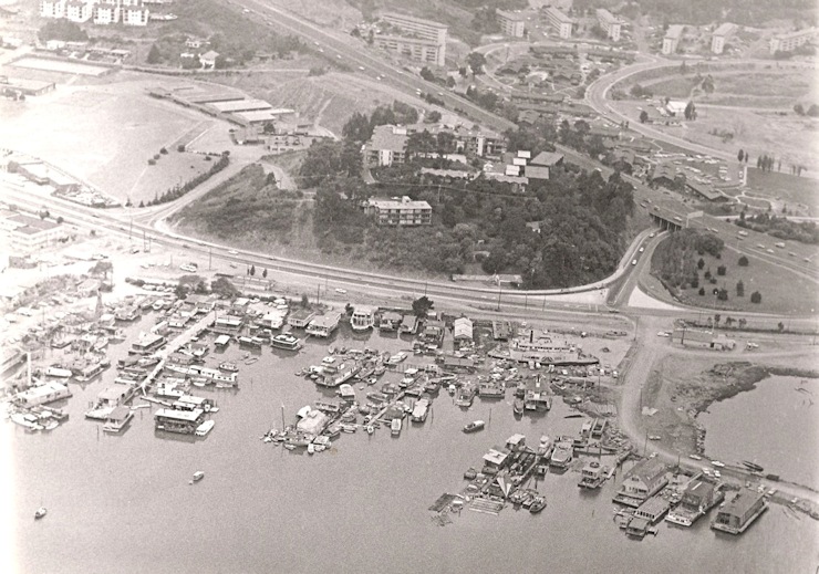
However, the state constitution, adopted in 1879, forbade further sales of tidelands within two miles of an incorporated city to private parties. By that time, 36 square miles had been sold, and 12 of them had been filled in. Richardson Bay, including Waldo Point, was not filled in, but was divided among many small owners: two dozen or more by 1980. This was the first deviation between law and reality.
After the earthquake and fire of 1906, some San Franciscans took up year-round residence on arks which had served as summer homes or weekend getaways in the Belvedere Lagoon and on Corte Madera Creek. Some of these arks were moved to Sausalito, especially to Waldo Point.
On the eve of WW II, C. L. Arques and his son Donlon were the two largest owners at Waldo Point, each owning four blocks. In 1942 the government seized Waldo Point under the War Powers Act, and it became part of Bechtel Corporation’s giant Marinship shipyard. After the war, Bechtel abandoned the shipyard, and in 1946 Don Arques purchased the Waldo Point property from the War Assets Administration. For the first time all Waldo Point blocks were under single ownership.
The property was full of debris and surplus war vessels such as landing craft, lifeboats and barges. Many of the people who had moved here to work in Marinship remained after the war, and some moved into Waldo Point. The existing houseboat community began to grow much larger than before the war. This growth went unregulated for two decades.
Back on the legal side, in 1959, the State Legislature turned the underwater streets over to the County of Marin. Then, in 1965, The McAteer-Petris Act was passed to restrict new “fill” in the Bay. “Fill” was defined to include any floating structures, such as houseboats and floating docks. Fill was permitted only for “water-oriented uses” or in minor amounts to improve shoreline appearance or public access to the Bay. “Water-oriented uses” included marine-related industry, ports, water-related recreation, wildlife refuges and airports. NOT housing.
The Bay Conservation and Development Commission (BCDC) was established to enforce these regulations, which applied to both privately and publicly owned lands (blocks and streets). The restrictions applied only to new fill. Anything prior to January 1, 1966 was grandfathered in.
But growth continued at Waldo Point, so in the late 1960s the County began to apply pressure on Arques to get a development permit to confirm preexisting use. By 1971 he had received permits from both the County and the BCDC. The BCDC permit authorized 265 houseboat berths, based on a judgment of how many houseboats were grandfathered.
The County leased portions of the streets to Arques through 2028, a move which was actually illegal based on existing statutes. State regulators later claimed that they had never been informed of the lease.
From 1971 to 1977, Arques did nothing to implement his permits, while the number of houseboats continued to grow as disenchanted hippies fled the Haight-Ashbury scene. The County eventually threatened Arques with large fines for his inaction, and he responded by signing a lease option with a partnership called Waldo Point Harbor (WPH).
Those developers soon began to implement the approved plan, but battles broke out between anti-development activists and County authorities. These conflicts are depicted in Charles Bush’s novel, Houseboat Wars.
Next week: The Rise of the Gates Cooperative