


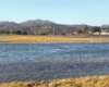
As floating home residents know, high tides over six feet routinely flood the Sausalito-Mill Valley path, making it impassable. With a predicted sea level rise of three to ten feet in the next decades, the problem will only get worse. The One Tam coalition assembled a design team (WRT/ESA) that includes local scientists who have studied Bothin Marsh and the path area to meet the community’s three goals: provide public access, protect and enhance the habitat, and prepare for sea level rise.
The Evolving Shorelines project group has released three alternative concepts and seeks feedback on which one the community prefers.
The choices were presented on Oct 15 to about seventy-five people who tuned in to hear details of the different options. Supervisor Kate Sears praised the choices and then introduced representatives from One Tam and the two design firms. Eddie Divita of ESA discussed the project area through the lens of conservancy: the marsh is eroding, suffering from a lack of sediment and tidal flow from Coyote Creek, and it needs to be preserved for birds such as the Ridgway’s Rail. John Gibbs of WRT noted one key benefit of all three plans that received unanimous praise: a wider path that separates pedestrians and bicyclists so people can move along the path safely.
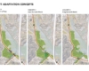
The design team’s three alternatives have different advantages and different price tags. The choices are:
Raise Trail in Place – Concept one accommodates up to two feet of sea rise, replaces two bridges, widens the trail on a raised living levee with lookout spots, and separates bikers and walkers.
Span the South Marsh – Concept two elevates the trail on a causeway above the full length of the marsh, allows for lookouts, and realigns Coyote Creek to redirect sediment into the marsh.
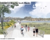
Ring the South Marsh – Concept three moves the trail to alongside the shores of Tam Junction, allowing the marsh to be restored and connecting to shops and cafés.
Please take 10 minutes to look at the three different concepts for elevating and/or moving the pathway and share your thoughts in the survey. The survey will be up through mid-November.
For more information about the project, visit Onetam.org/bothin. To read past Floating Times articles, read Rising Sea: Understanding Impacts to Bothin Marsh.