
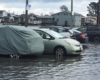


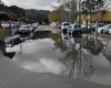

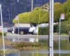


Sea level rise is for real, as we all witnessed around Thanksgiving. After the downpour of November 26, there was a light drizzle the following morning, yet portions of our parking lots and streets were inundated during what was supposed to be 6.5’ high tide.
Thanksgiving Day saw similar flooding by noon, in dry conditions during a tide that was only supposed to reach 6.1’. The bay is clearly swollen, so we need to be on the lookout for flooding at lower tides than ever before.
This month, we’ll be experiencing high tides of 6’ or more on the 10th through the 15th, then again from the 21st through the 27th, with king tides (6.6’ feet or more) from Dec. 23 through Christmas Day. Similar high tides will come on January 7-11, and again on the 18th through the 24th.
To determine the timing and height of these tides, check the interactive tide chart on the right side of this page; by clicking on the Day + button, you can advance to these dates and then, by positioning the target circle at the point of the highest tide each day, you can see when these tides will reach their peak.
Remember, rain and low-pressure fronts can increase the height of these king tides even more so avoid driving or parking in areas subject to flooding. And be sure to warn your visitors.