


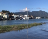


Last week, king tides reached seven feet and more, as predicted. The volunteer citizen scientists from Gate 6 ½ to South 40 were ready, and at about 11 a.m. on Monday, Jan. 21, everyone snapped photos of their yardsticks.
The results below are fairly similar to what we found in December. The main conclusion will not surprise most long-term residents of our floating community: storm surges make a big difference. When tides are combined with rainfall, we really see much more flooding. On Sunday, Jan. 20, both West Pier and Issaquah had readings that were three inches higher when it was raining.
| Dock | Height from dock to water |
| East Pier | over 36″ by 3″ |
| East Pier | over 36″ by 2-3″ |
| West Pier | over 36″ by 6″ |
| Yellow Ferry | 9″ |
| A Dock | over 36″ by 2″ |
| Issaquah | 36″ |
| Main Dock | 34″ |
| Liberty | 29.8″ |
| South Forty | over 36″ by 10″ |
| Gate 6 1/2 | over 36″ by 4″ |
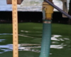
Last month, we made some assumptions about Yellow Ferry and Liberty Dock. One astute reader noted that Liberty dock height varies. The disparity is not known, but it may be lower at the far end, near where the yardstick is mounted.
Another reader pointed out that Yellow Ferry dock definitely slopes down to meet its parking lot, and so the yardstick reading there skews the findings. Nevertheless, Yellow Ferry is experiencing sea lapping at the sewer pipe below the dock. (See last photo above.)
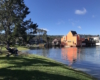
Our simple yardstick readings may give the impression that we are less than three feet away from shorted electricity and other worries, but the news is more grim. Access to parking lots and roads were blocked, which is an immediate concern, especially if these tide heights become the norm. A recent New York Times piece reported that scientists are warning of a tipping point—Greenland ice melted four times faster in 2012 than in 2003. Within two decades, it says, the southwest region of Greenland “will become a major contributor to sea level rise.”
Flooded roads and parking lots foreshadow what is coming unless we cut carbon emissions sharply. At the same time we need to urge our leaders to switch to renewable energy, we also need to think about adaptation. If you are interested in helping the Floating Homes Community prepare for sea level rise, please contact me at jengennari@gmail.com.