
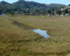


The area north of our floating community turns out to be the canary in the coal mine. Because of its location and geography, this end of Richardson Bay and Bothin Marsh will likely experience sea level rise earlier than most. Josh Collins, chief scientist of the San Francisco Estuary Institute, noted, “There’s nothing to stop water from the Golden Gate.”
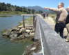
A group of scientists, parks staff, and leaders from Mill Valley, Caltrans, PG&E, and environmentalists gathered for two full-day workshops in March and April to understand what’s at risk and ways to adapt. I was invited to represent the FHA’s environmental committee.
Although the outlook is dire, the scientists hope to pilot solutions that could be useful around the world. “Bothin Marsh is a sea level rise laboratory for around the Bay and beyond,” said Roger Leventhal, a hydraulics and coastal engineer with the County of Marin.
History
For centuries, we’ve been reclaiming wetlands for agricultural uses and development. According to Collins, in 1899, the railroad trestle was put in across part of Richardson Bay, north of 101. That trestle caused the formation of Bothin Marsh, visible in 1927.
Compared to 1852, the size of Richardson Bay has decreased by 50% and the marsh decreased by 95%. In 1952 dikes were added and, in 1973, the area was dredged for navigation. By 2005, some of those levees were breached, with the unintentional consequence of reclaimed land returning to marsh. Today, thousands of people enjoy the wetlands by walking and biking along the converted rail trail.
Marsh health
Marshes depend on mudflats. Richardson Bay has a steep escarpment separating it from San Francisco Bay. (This doesn’t stop the water — only the sediment.) Sediment feeds into Richardson Bay from Coyote Creek and Arroyo Corte Madera, from Tam Valley and Mount Tamalpais. Right now, the marshes on either side of the multi-use path are unhealthy.
Marshes should not be flat. “An inch of height makes a big difference in how often it gets wet,” said Collins. Animals need marsh mounds to hide at high tide from falcons and rising water. Without varied terrain, at high tide the falcons think, “the buffet is set.”
The marsh edge is also eroding. You can see “slump blocks” when grass slumps off and washes away. During King Tides, you can see how a weir (a low dam) alters the flow of Coyote Creek, resulting in a change in the height of the river level.
One foot higher oceans would restore the marsh to historic levels of the 1850s. As the sea rises, wave energy will be stronger, so pulsing surf will change the physical landscape and shore edge. Animals will migrate toward land, and a wet transition zone will exist. Species will adapt their habitat by moving upslope as the water becomes more salty.
How high?
What most people want to know is the number and when. Will the water be 5 feet or 10 feet higher in 2100? How high will it be in 20 years? According to Collins, water is going to find someplace to go. “The ocean doesn’t have a calendar,” he said. “Expect surprises.”
The group will be hosting a series of summer gatherings to suggest adaptation solutions and to build consensus for the future of the marsh. Find out how to get involved on the Marin County website.
If you are waiting for scientists to tell you exactly how many feet, don’t bother. As Leventhal said, sea level rise height predictions are interesting but not what we should be focused on. He added, “We won’t know the number until the water is lapping at our feet.”