
“…I’m sitting on the dock of the Bay watching the tide roll away…”
Otis Redding
Life in a floating home makes you aware of tides since our homes rise and fall relative to our docks twice a day. The water comes from the Pacific Ocean as currents flow into the bay and then flow back out. These currents have interesting, even surprising properties.
Circular currents
Examples of circular currents are seen in Figure 1, a section of a nautical chart showing the currents as purple arrows. The overall tide is ebbing, flowing leftward or West under the Golden Gate bridge into the ocean. Just outside the bridge, the current is moving at 2.7 knots (3.1 miles per hour). However, along the Northern shore, just East of Pt. Bonita, the current along the shore is 1.0 knots to the East, the opposite direction. Along the shore to the South of the bridge the current is 1.5 knots East, also opposite to flow under the bridge.
These circular patterns can be understood as the result of Newton’s second law of motion: the rate at which the velocity of an object changes, its acceleration, equals the force on it divided by its mass. Velocity is the combination of both speed and direction. Thus, it would take infinite force to make a current change direction instantly, that is turn a sharp corner and flow into the bay. The same law controls the motion of your automobile when you change direction. If you are moving at high speed, you must change direction slowly or the friction of your tires against the road surface won’t be sufficient to direct your motion and the car will skid. Newton’s law means the current must also change direction slowly, causing more water to flow in at the far than the near shore. When large, this imbalance results in a reverse flow along the near shore.
In the simplified map of Richardson Bay, Figure 2, flooding tidal currents are shown. Our Bay, the light blue area, is only about 6 feet deep off of Waldo Point at high tide, and 15 feet deep at channel marker 2, the edge of an underwater cliff which marks the entrance to the Sausalito Channel. Past the cliff is a channel that extends from the Golden Gate Bridge, passes Northwest between Belvedere and Angle Island, and then goes North to the Sacramento River. This channel, Raccoon Straight, averages 150 to 200 feet in depth, and has currents up to 5 knots in either direction.
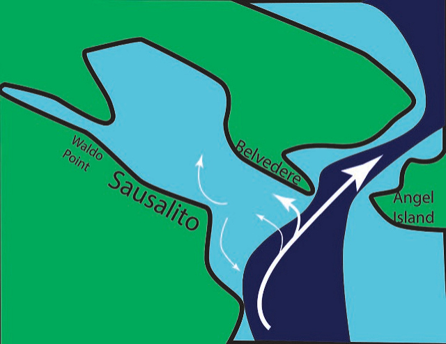
On a flooding tide, most of the ocean water flowing into Richardson Bay passes along the far shore, Belvedere, because it takes time (here distance) for the water to turn into the bay. The current along the near side, moving across the Sausalito ferry dock, is weaker, or can even flow back out toward the bridge. However, even when current is flowing outward here, the water level is still increasing, because much more water flows in across Belvedere than out past the ferry dock. Currents in the middle of Richardson Bay are smaller but complicated, and difficult to predict since they depend on the strengths of previous currents and tide heights. However, they often form gyres.
Animals ride the current
As I mentioned in an earlier essay most of the animals attached to our docks, e.g. mussels, barnacles, and crabs, develop in two stages. The first, larval stage is free swimming while the second is firmly attached or limited to crawling. The larval stage may last only a few days, and the swimming speed is so slow that they are classed as plankton, swimming slower than typical currents (1-2 knots). However, the important thing is that they are drifting in the current. The tidal current along the Sausalito shore is typically 0.5 to 2 knots. During an ebb tide lasting 6 hours, that translates into a distance of about 2-6 nm (nautical miles) being carried from the Sausalito shore to the Golden Gate Bridge. When the tide reverses, the larva could be carried to Angel Island or Crissy Field on the North coast of San Francisco. It is this way that invasive species, like the larval forms of zebra and quagga mussels, carried in the ballast water of ships, can populate the entire San Francisco Bay in just a few years.
Water fronts
During a flooding tide, cold, heavy ocean water meets shallow bay water that is usually warmer and thus less dense; it has been heated by the sun for 6 hours. At the boundary or front, Fig. 3, the current at the surface moves more rapidly that it does along the bottom creating a rotating vertical current on both sides of the front. As you see in the Figure, the sharp, upper air-water surface on both sides flows into the front and plunges down. The boundary between the two waters remains sharp because it is continually replaced by a new sharp water-air boundary.
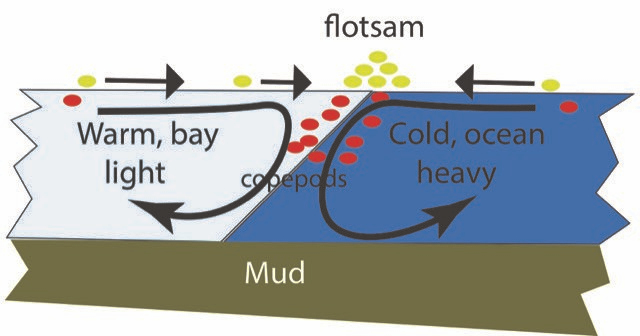
There is always some solid material on the water surface: bird feathers, leaves, pieces of wood and bark. This material is collectively called flotsam. If the water is relatively clean you may not notice the flotsam, but it is obvious when it accumulates along the front. It stays there because it isn’t pulled down under the water; a front is usually marked by a line of flotsam.
Animals in the water, e.g. copepods, are hunting food which is usually concentrated in sunny water near the surface. When these animals are swept to the front and then pulled down deeper, they resist by swimming up toward the surface to try to maintain their normal depth. This creates a high concentration of animals, a mirror image of the line of flotsam along the front surface. But copepods are just one link of a food chain. Small fish are hunting the copepods, and larger fish are hunting the small fish. All become concentrated along the front.
Bird fishers, like gulls and terns, have learned that fish are to be found under the flotsam line, and thus they feed along a front. If you see a stretched-out cluster of birds along a line of flotsam it is likely to be an active front. Clever human fishermen also learn that fish are to be found along fronts, which they can see at a distance because of the birds. Thus, fronts are an entire eco-community.
A very different kind of front can be seen at the edge of Richardson Bay when a strong current flows out through Raccoon Straight to the Golden Gate Bridge — particularly during late winter and early spring when the ebbing water is brown from silt washed down the Sacramento River. A sharp shear front can be seen between this water and the darker blue ocean water. If you watch the San Francisco ferry cross it, either from a Sausalito hill or the stern of the ship, you will see the wake sheared at the fronts on either side of the current which is only about 100 meters wide at this point. The segment of the wake in the brown current remains straight and intact for several minutes as it flows past the rest of the wake at a speed of several knots.
Weather (air) fronts
Weather fronts are generated when cold air, usually from the North, meets warm air, usually from the South. They resemble tidal fronts in many ways. The boundary between the two air temperatures is more stable than you might think because of air flow patterns. Cold air pushes under the warmer air, so the front surface is tilted vertically. The warm air often contains more water than is stable at the colder temperature, so it rains or snows at the front, and it’s almost always windy. Fronts are where the weather action is and indicate where it is moving. Thus, many weather maps indicate fronts with color coded symbols to indicate type and direction of motion. These weather fronts are spread over hundreds of miles, distances several orders of magnitude greater than the tidal water currents in our bay. These large air currents are strongly influenced by forces due to the rotation of the earth and often form spirals similar to the tidal currents we have discussed earlier, formed by a different mechanism.