The City of Sausalito wants to hear from you about the City’s Plan to protect the shore — including all houseboat marinas as far north as Commodore — from flooding that will come with steadily increasing high tides.
The level of the Pacific and the Bay, measured by satellite, has increased 5 inches in the last 50 years. Federal, State and regional authorities predict it will rise another 10 inches in the next 25 years. A major storm surge could push another 3.5 feet ashore.
The Sausalito Shoreline Adaptation Plan was reviewed at a community meeting with the City’s consultants on September 10th at the Sausalito Center for the Arts. This was the third public meeting that has shaped the plan with community input for the last two years. The draft plan was funded by a $1-million State grant won by former mayor Janelle Kellman. It is to be presented to the City Council later this year. You can find and comment on the presentation on the City’s website.
The cost of doing nothing to prepare, calculated by WT Design at current replacement cost, could be between 160 and 570 million dollars. Adaptation might cost more, according to John Gibbs of WT Design.
Gibbs said that community opinions gathered at previous public meetings identified maintaining Sausalito’s character as a town by the sea and retaining the working waterfront as the first two priorities for planning. The draft plan, he said, was guided by those community priorities.
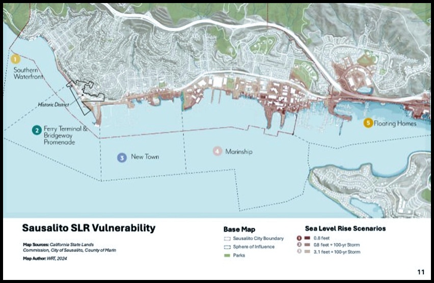
The consultants identified five separate zones along the shoreline based on different vulnerabilities to flooding, Gibbs said. The map shows all five zones, including floating homes in Zone 5.
Floating home marinas north of the city limits were included in the City’s planning at the urging of the Sausalito Sea Level Rise Task Force, which included two floating homeowners.
As presented, the draft Adaptation plan recommends a defense strategy blending a built-up armored edge at the shoreline and floating solutions near shore, such as floating buildings, docks and infrastructure. Both, Gibbs said, could be supplanted by natural solutions along the shore, including floodwater runoff ponds and marshes. Gibbs called this approach a resilient edge and pointed out that Galilee Harbor is seeking grant funding for a near-shore wave attenuator. If you’re curious there’s one of those along the eastern edge of Clipper Yacht Harbor.
Whether or not you were able to attend the meeting, members of the public are encouraged to review the draft plan and fill out the feedback form by October 7.
Hard copies of the draft plan and feedback form are also available at the City Hall administration desk and at the Library.