My last post in these pages described the process of finding the mean sea level at Sausalito with twice daily high and low tides averaged out. Now let’s drift out the Golden Gate and turn North ten or twenty miles to expand our view of the ocean surface.
Current flowing down the coast
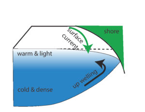
Along the Pacific coast the water and wind usually flow South. It is not coincidence that they flow in the same direction, for the wind is the major driver of the California current, which extends South to Point Conception and North past Washington State. As the water moves along the coast toward the equator its distance from the axis of the rotating earth increases, and thus its Eastward velocity must increase, it must accelerate, to remain along the coast. Acceleration requires force, the coast must pull the current along with it. This is partially successful, but surface water moves away from the coast creating a downward sloping surface, drawing deeper water up to replace it, Fig. 1. We can see this upwelling along the coast because the water is darker and cooler. We could see the water pulling away from the shore if we could measure the height of the water accurately. Spoiler alert: using satellites we can.
The deep water is also rich in minerals, which most ocean surface waters lack. These minerals allow for rapid growth of phytoplankton, which are eaten by zooplankton, and on up the food chain. Along our Pacific coast the upwelling supports large schools of salmon, or at least it did before the salmon were overfished and blocked from spawning up rivers by dams. Along the coast of Chile, a similar upwelling produces massive stocks of anchovies. This cold water along the California coast also generates our familiar summer fog which condenses out from warmer moist air flowing Eastward over it.
Drift back to 1957
I was a sailor in the Naval Reserve, and left San Diego on a late summer afternoon onboard a destroyer in dark green water and high fog. The next morning when I came up on deck to get in the chow line, we were past the zone of upwelling, more than 200 miles off the coast. The air was warm, the sun bright, and the water blue, like a post card. But this beautiful water can support little marine life, as many of our unfortunate downed naval aviators discovered during WWII when attempting to catch fish from their life rafts.
Several months later, the evening of October 4, I was a junior at Caltech wasting time in the dorm’s lounge instead of doing my homework. Several classmates burst in yelling that the Russians had put a satellite in orbit above us, and it was being monitored at Kellog, the high energy physic lab. We rushed over and saw long strips of chart paper taped to the wall in the hallway. The chart recorded a radio signal at 20 MHz, a common short wave frequency. The signal consisted of a group of tone pulses every 0.3 sec, rising and falling over several minutes, repeating every 96 minutes, with the tone a slightly higher frequency before and slightly lower after the maximum. This shift in frequency was clearly a Doppler effect, from which the velocity could be calculated. The overall period of 96 minutes was that expected for a satellite orbiting about 500 km above the earth, and the velocity calculated from the Doppler shift was consistent with that orbit. The Russians gave these same parameters on short wave, and it all fit. It was just a freshman physics problem.
Satellites have changed the world
This satellite, named Sputnik by the Russians, had dramatic political and economic effects in the US. We were surprised, alarmed and embarrassed that Russia had pulled off this feat before we had, for we had a serious program of rocket development since WWII, alarmed by the obvious military potential of rockets like the V2s that Germany had used against England.
Newspapers ran headlines asking if Russia was now going to drop bombs on us from satellites like Sputnik. Of course, you and I know this is nonsense, since we watch astronauts on television work in the International Space Station. When an astronaut “drops” a pencil it just floats along near her hand; it’s still in the same orbit around the earth as she is, and doesn’t fall to earth.
Sputnik triggered a huge increase in government spending for research and development and lavish support for education in science and technology over the next 10 years. Since then, with fluctuations, it has remained high. The effects of the second chaotic Trump administration, including downsizing the popular National Institutes of Health, are not yet clear, since many are being challenged in court and may be reversed by congress.
Satellites enabled reliable global communication for the first time and provided high resolution images of most regions of the earth. They map methane flairs, extent of ice cover in the arctic, agricultural activity. They have revolutionized astronomy, enabling high resolution studies in the far infrared, a part of the spectrum blocked by gases in the atmosphere. Satellites have made so many things possible, including our topic here, measuring global sea levels.
Satellites provide global reference frames
In Sausalito we used a mark on a piling to define our mean sea level. To extend the concept of sea level over the earth we need a global reference grid to replace the piling. We need to be able to make a mark on a piling In New York harbor and say is at the same height as our mark in Sausalito. Then, if the mean water level in New York is at that mark we can say sea level in New York Harbor is the same as it is in Sausalito. Creating and interpreting marks on virtual pilings will require two global grids, and two corresponding satellite systems.
The first grid Is an oblate ellipsoid which matches the earth’s surface at several fixed survey markers and defines the lines of latitude and longitude. The survey markers are typically brass discs, 10-20 cm in diameter with an engraved cross to indicate the center, and text for identification. They are usually imbedded into the tops of concrete posts, so they don’t move and to make it difficult to rip off the brass and sell it. Of course, the ellipsoid can only exactly match the earth at a three points, so mountains poke above and some valleys sag below its surface. Moreover, the surface of the earth is not static when we care about distances as small as millimeters, since the earth’s surface consists of many irregular tectonic plates, which move relative to each other. The North American plate moves tens of mm per year relative to many other plates. Thus, when in Europe, on a different plate, we wouldn’t use the American markers. Meaningful definition of precise locations over all the earth’s surface requires a complex system of updating and documentation of standards by committees from the international community. Just one example of the dependence of modern technology on international cooperation.
Position, relative to this ellipsoid, is determined using the Global Positioning System (GPS), which consists of about 24 satellites that move in different orbits 20,000 km above the earth. Several ground stations are used to coordinate and calibrate the satellites. The first satellite was launched in 1978 and was motivated mostly by military needs. Similar systems have since been created by other countries, including Russia, China, India and the EU. Successive systems have increased accuracy and ease of use, making the capability to determine position a customary part of civilian life all over the world. The accuracy of GPS depends on many factors, such as duration of observation, size of the antenna, stability of the receiver, and ability to correct for atmospheric conditions. However, if motivated one can get positions in all 3 dimensions with mm precision, more than adequate to measure the creep of tectonic land plates spanning an earthquake fault or compare the sea level at Sausalito with the sea level in New York harbor.
Position is determined by the times required for radio signals to travel from the satellites to GPS receivers and relies on the fundamental constancy of the velocity, c, of all electromagnetic radiation in a vacuum. Time is the physical observable which, with present technology, can be measured to greatest accuracy, and it is determined in the GPS satellites by atomic transitions, electronic oscillations, of cesium atoms. These clocks are corrected for use by the fixed GPS receivers on earth, using the velocity of the satellites and the special theory of relativity. The GPS receivers on earth don’t require very accurate clocks since determining time differences and using them to calculate a position is done using information encoded in the satellite signals themselves.
Secondly, to obtain meaningful values for sea level we need to define and then determine a second reference frame, or rather a surface. Latitude and longitude are fine, but zero on the vertical scale should have a simple meaning; it should define a sea level when all possible variables which might affect sea level, except latitude and longitude, are the same. This surface should be an ocean with no wind or currents, constant atmospheric pressure, temperature and salinity, no forces due to attractions of moon and sun, because we are talking about the mean sea level. So, what’s left?
Gravity
Water is held to the earth by gravity. We usually think of the earth having a constant gravitational field. But gravity is the force observed between any two masses that can be approximated as matter concentrated at points. For the purpose of calculating gravitational force a sphere of constant density is equivalent to a point mass. We might approximate ourselves or a cubic meter of ocean as a point, but the earth is hardly a point and it’s certainly not homogenous. Mass is equal to density times volume. The density of water is about 1000 kg per cubic meter, but the density of granite is more than 3 times greater. The force of gravity decreases as the square of the distance separating the masses, so the density closest to you is the most important. If you are in a boat in middle of the Pacific Ocean, which has an average depth of almost 4 km, the gravitational field will be noticeably smaller, a good fraction of a percent, than if you are standing next to a massive granite mountain with its granite foundation. The surface of constant gravitational force around the earth is called the geoid, and it has been measured with several satellite systems.
Determining the geoid
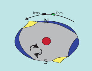
In 2002, the multinational satellite system GRACE (Gravity Recovery and Climate Experiment) was launched. GRACE used two almost identical satellites, named after the cartoon characters Tom and Jerry, which orbited the earth on a polar orbit about 200 km apart, Fig. 2. As Tom chased Jerry the distance between them was measured using a radar signal created by one and reflected back by the other, and was determined with an accuracy of about 0.01 mm. As Tom and Jerry passed through regions where the earth’s gravity changed their separation changed, since each was then subject to different forces. The separation differences were processed, or integrated, to produce the height of the geoid along that path. This system was very successful and subsequentially the GRACE-FO, (GRACE Follow On), satellite pair was launched and is still collecting data as of December 2025. The FO pair uses lasers to determine separation with 100 fold greater accuracy than GRACE.
Is measuring the geoid only about small differences? Not really, the geoid is about 100 meters lower than average in the South Indian Ocean, and 80 meters higher than average over New Guinea. That range is certainly a lot greater than any daily tide change.
Accurate measurements of the geoid, particularly changes over time, have many uses not related to the ocean surface or the paths of ballistic missiles. Changes in the geoid have been used to follow melting of Greenland’s glaciers and falling levels of the water table due to agricultural use in California’s central valley. Any process that changes the distribution of mass on the earth changes the geoid; you just need sufficiently sensitive instruments to measure it.
Looking at the Earth
Many satellites directly monitor, i.e. just look at, the Earth. If you put a diffraction limited telescope with a 48 inch mirror in orbit a few hundred miles above the Earth, you can read a book on the ground, or at least the title page. That’s about the size of typical military intelligence satellites, and many now orbit the earth. But there are other ways to observe the Earth from space, and each technique reveals different features.
A recent example is the NASA-ISRO satellite launched on 30 July 2025, which uses a synthetic aperture radar operating at both 5 and 10 cm wavelengths. This joint US-India project uses an antenna 12 meters in diameter, the largest ever stent into space by NASA, which was folded while in the launch rocket. It can map the surface of the ocean with cm accuracy and collects data day and night as it orbits the earth at an altitude of about 700 km. In just a few weeks you generate a high resolution map of sea level on all the oceans. This same radar can follow the earth’s land surface under trees, if the forest canopy is not too thick, and characterize agricultural crops.
Many factors affect the ocean surface
The force of gravity on the ocean at one location is product of the gravitational field times the water’s density. When water warms it expands, its density decreases, gravity exerts less force and it rises relative to cooler water around it. The Gulf stream is a wide, deep, and very warm band of water that moves North along the Southern half of America’s East coast. Since it is warmer than the surrounding water it is higher and can be followed by a surface mapping satellite.
Fresh water has lower density than saltwater. Thus, the outflow of the Amazon River can be seen as a tongue of higher water flowing out over the ocean by a surface mapping satellite. Storms change the ocean surface both by their circular cyclonic winds and by the lower atmospheric pressure in the middle which causes the water to rise relative to the surrounding ocean.
The interior of the earth doesn’t have constant density. In the region below the surface crust, but above the hot core, very viscous material of variable density slowly churns in an irregular pattern only partially understood. It is this material that is believed to be responsible for the lowest region of the geoid in the South Indian Sea.
Sea level is a surface
We started out just measuring the mean sea level in Sausalito. To extend this to oceans around the world we had to establish a global reference ellipsoid anchored at 3 points on land. This ellipsoid changes with time because the earth’s surface is composed of tectonic plates which move. In addition, we needed to determine the surface of constant gravity, since gravity varies with position and composition of the earth. Sea level is a dynamic, flexible membrane defined by many factors, including temperature and pressure patterns of the atmosphere and density variations hundreds of km under the earth’s surface.
An argument has been made that, for us, tectonic plates are a feature, not a bug in our Earth’s machinery. Partially motivated by observations of planets in other solar systems, again made possible mostly by satellites, it has been proposed that planets with a solid surface must either be dry, if the chemistry for water isn’t present, or completely covered with an ocean if it is. Life as we know it, cannot evolve on a dry planet. However, if life was confined to an all water world, would the aquatic animals be reading books, programing computers, and using telescopes? Tuna and octopi are wonderful creatures, but their water environment imposes limitations. Only a planet with jumbled tectonic plates may have a sufficiently rough surface for dry continents and oceans to co-exist. We are learning so much about our earth and the universe, what an exciting time to be alive!
References
The best single site for information on subjects described in this article is Wikipedia, and these are several relevant search terms: Upwelling, Sputnik 1, Global Positioning System, Geoid, GRACE and GRACE-FO, NISAR (satellite).