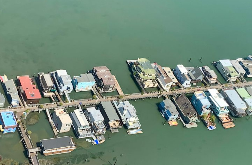
Visitors to our community frequently notice what appear to be vacant berths on the docks. They’re always amazed to discover that these openings are actually underwater streets, vestiges of unrealized plans to fill in Richardson’s Bay back when California first became a state.
According to a paper by Michael Wilmar, ex-director of the Bay Conservation and Development Commission (BCDC) and an attorney specializing in real estate, land use and natural resources, “when California became a state in 1850, it acquired title from the United States to all of the tide and submerged lands within its new boundaries.” Shortly thereafter the cash-strapped State Legislature began to authorize the sale of tidelands and set up a Board of Tideland Commissioners to oversee the process.
In Sausalito, a group of investors bought several parcels and the Saucelito Land & Ferry Company (as it was known then) had a survey completed and a map drawn up showing future streets and lots available to the public. A copy of the 1875 Saucelito Land & Ferry Company map hangs outside the Historical Society rooms at the Sausalito Civic Center. At one point the plan was to fill in all of Richardson’s Bay, creating a West Coast Venice with canals connecting the Sausalito and Strawberry shores.
In 1879, a public backlash against the sell-off of the Bay led to a new provision in the state Constitution forbidding the sale of tidelands. Submerged lands already in private ownership were declared a public trust, with the guarantee of public rights to reach and use navigable waters.
The state retained title to the underwater streets, as a way of establishing boundaries for future development. The State Lands Commission, founded in 1938, took over stewardship of this underwater real estate.
When the BCDC was formed in the mid-60’s, Sausalito’s northern waterfront was a jumble of residences cobbled together from old vessels, war surplus, and spare parts, sheltering a gaggle of self-described “boatniks.” To clean up the community, the County and BCDC authorized the construction of floating home marinas, which would provide shoreside hookups for power, telephones and—most important—sewage. Where a floating home dock crossed an underwater street, no home could be berthed.
Over the years, the old houseboats morphed into floating homes. Many grew to two or three times their original size, or were replaced altogether by larger, more elaborate residences. In time a few encroached on the mythical underwater streets, creating a new hot topic in always-Byzantine waterfront politics: Boats on Streets.
BCDC permits for the three largest marinas (Waldo Point Harbor, Yellow Ferry Harbor and Kappas), lapsed in the early 90’s. To renew the permits, the BCDC demanded mitigation for un-permitted growth, including Boats on Streets. In the case of Kappas, a land swap was arranged, with Kappas buying underwater lots to trade for the public trust streets under its docks and residences.
However, soon after the swap was approved, a Southern California court case successfully challenged the State Lands Commission’s constitutional right to sell or trade undeveloped offshore property, so it became necessary to pass legislation authorizing the Commission to enter into agreements with Marin County and Kappas for the land swap. The bill passed through the legislature unchallenged, and was signed by Governor Schwartzenegger, opening the way for Kappas to file for its BCDC permit.
To date, only Waldo Point Harbor has successfully renewed its BCDC permit.