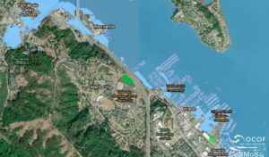
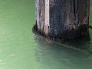
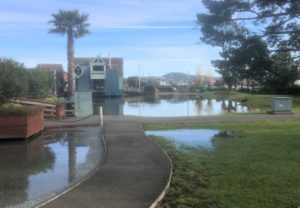
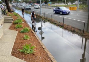
More King Tides Ahead

During the early winter months, the combination of the lunar phase and the solar perihelion (when the earth is closest to the sun) can generate especially high tides, also known as king tides. King tides that exceed 6.5′ typically cause street flooding in Sausalito, most often on Gate 5 Road...

Flood Control for Marin City

If you’ve ever been caught in a flood on the Marin City off–ramp from Highway 101 south, or been forced to detour around it, you’ll be encouraged to learn that the Marin County Flood Control and Water Conservation District (the “District”) Flood Zone 3 plans to make improvements to the...

Projecting Sea Level Rise in Richardson Bay

Climate-induced sea level rise and flooding are expected to have a huge impact on the communities bordering Richardson Bay. To help residents better understand what is being done to prepare for these impacts, the County of Marin and a group of regional partners have created a new interactive website, Richardson...

More King Tides Coming

King tides (tides over 6.5’ high) are due in December and January, with tides exceeding 7 feet in mid-December. If accompanied by rains, these tides could flood parts of our parking lots, Gate 5 Road, the Manzanita parking lot and the multi-use path. Below are the predictions for higher than normal...

Last King Tides of Winter Coming Soon

Tides of 6.5’ or more are predicted for February 7-9, with the highest tides on Friday and Saturday mornings. To determine the exact times of these high tides, check the interactive tide chart on the right side of this page; by clicking on the Day + button, you can advance...

The Roiling Sea

Sea level is not level at all. Just as the surface of the earth is not flat, the surface of the ocean is not flat. Because the earth rotates to the east and because the ocean responds slowly to the rotation* and the surface of the sea piles up along...

Predicting Abnormally High-Water Events

As described previously, tide tables are merely estimates calculated by averaging the highs and lows for the last ten years and projecting them forward for the coming year(s). During periods of rain, tide tables must be adjusted to higher levels than forecast. Here is a high water level forecasting tool...